This
is the last of a series of blogs on the 2013 Uttarakhand devastations.
In my earlier blogs I
have made a somewhat detailed study of the Himalayas, solely to
add (in my opinion) credible substance to them in the hope that they will serve
the purpose of putting forward an opinion for serious consideration by some who
see a point in these efforts being made to limit damages by human interference.
In this blog I examine the safety of the Tehri dam in the context of what I have learnt from the previous blogs.
It
has been difficult to write accurately on a subject that I am not familiar
with. I somehow felt that as a senior educated citizen of this country I have
to make a serious effort in understanding the problem with dams and
hydroelectric projects in Himalaya. My effort may suffer because of inaccurate
technical terms. Most of my information and images have been from the net.
Where
my blog may differ from other is my emphasis on treating the Himalaya as a pile
of sand and emphasizing the critical threshold slope angle of 35o
above which avalanches and landslides occur. This critical angle holds for dry
sand and changes drastically when the soil/sand is wet. Threshold slopes which
are stable in dry weather start sliding to lower slope angles in heavy rains
weather or when soaked by, say, the waters of a reservoir. Added to this is the
problem of whether the rocks are sandy (quartz-like) or clayey. It turns out
that around the Tehri dam the rocks are 65% clayey. Because of the very
economics of it the rocks used for the rockfill of the dam have to necessarily
contain clayey rocks if extreme care was not taken. Itmay not have been taken. Then
it turns out that the rocks around Tehri are highly fractured and ridden by
earthquake fault lines. Such fault lines could be reactivated by the sheer load
of the water. There are ominous signs of a steep increase in the frequency of
earthquakes not only close to the dam but far away from the dam,
These
considerations should severely warn us about insisting on these misadventures
in the very fragile North-eastern parts of our country. Our country does not
consist of Delhi alone.
This
blog attempts to detail the reasons for wondering whether the dam damns us not
only for being careless as engineers but for being corrupt in dimensions which
our “moral crusders” dare not touch. It may also answer the question of why
foreign contractors stayed away from building the dam.
At
the end of it, the blog turns out to be very long and perhaps too technical. This
cannot be helped. The reasons for this is given at the end in, what I call, a
Blog Uncertainty Principle. It applies to all my blogs when I prefer being
accurate than just being readable.
Introduction
Earlier blogs were meant to examine
the fragility of the Himalayas. This blog is meant to examine some of the
engineering and geological issues involved in constructing hydro-electric
projects in the Garhwal Himalayas. There is (criminally unpublicized) awareness
that much of the devastations can be linked to activities related to building
of hydroelectric projects all over Himalaya, including Arunachal Pradesh which
has the most vulnerable hill slopes.
Sometimes there is little conviction
in public pronouncements of grief. Some of the most copious tears shed by us on
the devastations could have come from those who contributed to it most,
wittingly or unwittingly. It is
time, I guess, we stop wringing our hands and squeezing out the fabric of
Himalayas wet with our crocodile (not Ghariwal) tears for petty commercial
benefits.
There is an advertisement that appears
on TV nowadays which sings “mera desh ro raya hai” (my country is crying) with the very believable
Amitabh Bachan reciting “Garhwal kho gaya
hai” (Garhwal is lost). It sounds convincing and stirring --- if one has
not read an article “Hydelgate: Why Arunachal Pradesh’s hydel boom is going
bust” in Economic Times of 30 April 2013. This article says:- “The company
with the maximum number of licences, 12 in all, to build and operate
hydro-power projects in Arunachal Pradesh is Energy Development Company (EDC).
Amar Singh, the former Samajwadi Party leader, is its chairman, and actor
Amitabh Bachchan was on its board till July 2011.”
There is, of course, a huge tragedy
that has developed in the Himalya. In a paper by Raj Pandit “Other Factors at Work in the Melting
Himalaya: Follow-Up to Xu et al. Pandit 2009 Conservation Biology,
Volume 23, No. 6, 1346–1347” we find that in the Himalayas the following:-
“… the imminent danger
comes from organized developmental activity, such as hydropower generation and
dam building across Himalaya, As many as 280–300 small and large dams are
likely to be built on the Himalayan rivers in India across five
Himalayan
states …”
Professor M. K. Pandit of Delhi
University has written several scientific papers on Himalayan Ecology as well
as several Environmental Impact Assessment (EIA) reports on projects in
Himalayas. What struck my attention was an incredibly ominous statement (even
if four-years-old) in this paper which says “… the rivers are likely to flow inside tunnels for most of their
courses and are likely to become reservoirs … .” This should really make the country
cry. These tears will not be crocodile tears. They will be the tears of our own
critically endangered Gharial crocodiles,
I think that as ordinary hindusthani (this term does not exclude
followers of Islam, Christianity, or even Vishal Hindu Parishad) mortals of the
perennial kind we owe it to our spiritual well-being that we question why we
should hide-in-tunnels/store-in-dams/de-oxygenate-by-de-gurgling our gurgling
mountain streams for the purposes of generation of energy of the hydroelectric
kind at the expense of all our accumulated spiritual energy of all local
wisdom/experience kind.
Professor Pandit’s wariness is
typically found in early environment impact assessment (EIA) of such projects (e.g.,
from Chettry’s re-assessment of EIA of Arun-III hydroelectric project in Nepal)
“The project … came under criticism by
local, and some western, NGOs and individuals as being risky, costly and liable
to bring about severe environmental and social impacts. Consequently the
project was dropped on institutional, national, economic and financial grounds.”
Such concerns have now been set aside. We now have the ambitious projects all
over Uttarakhand that is given in Fig 1 below.
In this blog we examine the making of
the Tehri dam, the biggest such project in the fragile, young, threshold slopes
of the Himalayas. We do so not only because it has already been built and
commissioned for all to see but also because the building of the Tehri dam has
been trumpeted as a shining example of the power of Indian Engineers in
delivering world class hydroelectric power technology. It has been built after
fifty years of consideration and reconsideration of protests from local opinion.
During this time the ethnic character of the Himalayas has changed from
hillpeople towards plainsmen, some of its natural ecosystems have vanished, and
its population has increased ~ 4 times compared to a national increase of ~ 3
times.
Have we been foolish beyond
redemption? At least, for this life?
Soaking of Threshold Slopes?
For his obituary “Per Bak,
Physicist of Sudden Change, Dies at 54”, (29/12/02 in New York Times)
George Johnson wrote:
“.. it is
impossible to predict whether a particular grain will cause a tiny, barely
perceptible shudder or a catastrophic avalanche” (in a sandpile).
In the context of Himalayan landslides,
the above is another interpretation of the more well-known school poem:
“Little drops of water, little drops of sand
make the mighty ocean and the pleasant land.”
When one has Per Bak’s uncertainty with a single
grain of sand on self-organized sandpiles , one must avoid perfunctory actions,
such as making roads and dams on threshold slopes for business men --- or even
for pilgrims --- who will not walk.
In previous blogs I had
emphasized (at least to myself) that, based on the recent publications of
Larsen and Mongomery, the steep tectonically active Himalayas may be treated as
sandpiles with a slope close to 35o. This is probably an explanation
for statements such as “Numerous previous
studies of steep landscapes suggest that large changes in long-term erosion
rate lead to little change in mean hillslope angle”, when measured at
coarse (or long-range) resolution (see abstract of Hillslope response to tectonic forcing in
threshold landscapes, by DiBiase et al, Earth Surf. Process. Landforms, 2012)
These landscapes are designated as threshold landscapes. Earlier views
on threshold landscapes were that they were those where, because of
rock-strength limitation and hillside erosion, hill-slope angles are not greater
than 35-40o. However, local slopes can become larger when there is
rock-outcropping. One insight on using
the sandpile model for sand/soil slopes close to 35o is that no
matter how much one tries to reduce its slope --- by leveling it in the middle
for building a road, for example --- is that it becomes unstable to another
landslide that restores the critical slope. If one firms up the slope by rocks
(either naturally or by artificially) one only delays the landslide. A more
catastrophic avalanche results as in the case of the landslides where a large
rock has delayed a landslide.
These
aspects have been discussed in the context of my blog on Friday, August 2, 2013,
on “Himalayan
Instabilities: What One Wanted to Ask but was Afraid to Know.”
Among the parameters studied in
threshold slopes is the relation between rock exposure, erosion rate and the
distribution of local slopes. The effect of placing rocks to prevent landslides is
perhaps equivalent to slightly wetting the sand such that the sand particles
stick to one another and do not flow freely. In this case one may generate
slopes which are steeper than the critical angle for dry sand (middle of Fig 1of
blog of 2nd Aug 2013). However, if left to stand, a series of
avalanches will spontaneously occur with increasing drying that restores the
slope to its critical angle when the sand is dry.
The more dangerous aspects
that requires further study is the effect of prolonged wetting due to heavy
rainfall or due to prolonged soaking, such as those on the shores of dams. The
critical slope for a sandpile is always dependent on the effective viscosity or
granulairy of the “wet” sand-water composite.
Piling sand on sand always requires first of all that the sand particles
are discrete and that a collection of packed sand particles can be found on
which another sand particle may be placed. Too much wetting will make the sandpile
act as a continuous liquid-like medium. Such a medium would be unstable to flow
and mudslides when the slope is increased. When there are “dry” slopes close to
35o, the critical sandpile angle, there could be possibilities mudslides
when there is heavy rainfall.
There is another danger of dams built on stratified hard and weak
rocks which we have approximated as “rock-soil” layers (Fig 2, left) for
Himalayan Landscapes. These dangers may not have been taken into account
specifically. The first of these is that “soil”-layers between rock slabs could
become soaked due to excessive wetting. If the soil is clay-like, the wet clay
would swell tending to expand the layered “rock-soil” composite as shown in a
somewhat exaggerated form in Fig 2, middle. The pressure exerted by the water
held within a soil or rock that causes the swelling is called the “pore
pressure”. This tendency to swell could
be overcome by the slipping away of the muddy layer as a mudslide which would
carry along with it rocky slabs. Such a mud/rock slide could be similar to the
more familiar phenomenon of a bar of soap sliding from its tray when a soapy
solution forms below the soap due to wetting. In drier weather, there will be
more bedrock exposed and the steepness of the slope would increase because of
the rock outcropping.
The extent of rock-outcropping and steepness of slopes of exposed
bedrock has been related to tectonics with high resolution light radar (LiDAR)
measurements. This must be important as far as building roads and dams are
concerned. As I wondered in the previous blog ( 18th August 2013, Fig
6), the only way that one can account for the huge volume of Himalayan soil in
the Bengal Fan of the Bay Bengal is to assume that the plate tectonics is a
huge pulverizing factory that grind the rocks into clay/sand which is then
carried away into the Bay of Bengal. The way the figure below is given, what
looks like solid rock on top can be pulverized rock or sand below the surface.
This clay/sand may be washed down through subterranean gorges and come out
along with the water that forms our mighty rivers.
Alternatively, the swelling of the soil layer would impose a
pressure on the rock-layers and tend to crack them. Moreover, when the wet soil
layers dry they would shrink. This expanding-drying cycle could also result in
the rock-layer cracking further (Fig 2, right) and add to the crushing,
sand-forming, mechanisms. After several wet and dry cycles, the highly degraded
rocks on a slope may behave very similar to soil/ sand composite and become
unstable. Such unstable slope areas are usually treated by rock bolt/nail techniques
(typically by inserting tensioned-bar rock bolts being 1-2” in dia and 3-6 m
long with a tensile working load of about 100 kilo Newton. Unit of force).
Ever since I first saw pictures of Gomukh (cow’s mouth source of
Ganga I have always asked myself why the water coming out of the mouth (see
inset of Fig 3, left; click to expand) where Ganga begins, is muddy at the
source itself. Actually a glance at Fig 1 shows that the actual source of the
Bhagirathi River is not at Gomukh itself but much further up. Indeed, on
looking at google maps I became further educated to find that there are two
Gomukhs! They are marked by red arrows in Fig 3, right. There is a narrow
stream entering into Gomukh on the right (east) and exit-ing on the left (west)
as the familiar broad muddy river, that makes up the summer Ganga There is only a ~ 600 m distance between the ice/sand
cavern that forms the east and the west Gomukhs. Such caverns are always formed
in the mountains during winter by frozen ice on streams and they all have the
shape of cow’s mouth, What could make the Gomukh on the Bhagirathi unique is
that there is such a broadening of the stream between the time it enters and
the time it exists. It is as if there is a subterranean river that emerges from
the west through a huge pile of sand/clay/soil (such as that illustrated in the
right of Fig 3, left) that feeds the Ganga in that stretch between the two
Gomukhs. It is in the west Gomukh that Ganga seems to get her character and
where the veneration begins!?
The mythology associated
with Bhagirathi is that ganga has to flow continuously from Gomukh to the sagar (sea). It is considered sufficient
to satisfy this mythology the water from upstream to downstream is made to flow
continuously using a 40 cm diameter pipe that allows the water to flow across the
dam body and to exit at the toe of the Tehri dam (see Fig 9, bottom).
Thus was the mighty Ganga
satisfied?
Now I think I am beginning to understand. Himalaya is indeed a
porous pile of sand that must be revered and venerated.
Fears about the Tehri dam
I do not know how such considerations could have been taken into
account when planning dams on threshold slopes built on flaky young metamorphic
sedimentary rock-types of the Himalayas.
One of my day-and-nightmares is that a collapse of the wet shores could
occur with the Tehri dam (see Fig 4, left for a sketch of the layout of the
project and Fig 4, right for some geological aspects). I remember conversations
with earthquake engineers from Roorkee University long ago where I voiced some
of the concerns in this blog. These were mostly about the soaking of the
reservoirs sides. I don’t think they
paid more than a polite attention to my arguments. What was more worrying is
that they may not have considered such a possibility simply because they may not
have been found in their text books that were based on experiences of the
non-Himalayan kind. I have since
improved my understanding in the specific context of the Tehri dam.
The Tehri dam is built 1.5
km downstream of the confluence of Bhagirathi (starting from Gomukh) and the
Bhilangana river (see Fig 1). The rocks around the river gorge are mainly of
the Chandpur phyllite kind. Chandpur phyllite are folded and are of
grayish green color probably of the kind shown in Fig 5, right. The rocks
here have undergone various magnitudes of tectonic deformation and have been
summarized in the 1988 article as cited in Fig 4, right. Grade I Phyllites are massive
in character and are predominantly arenaceous (describing rocks or deposits
that are composed of sand grains or have a sandy texture). Phyllites of Grade
II are conspiciously
banded with alterations of arenaceous and argillaceous (sedimentary
rock that is made up of clay or silt particles) and Phyllites of Grade III are
mainly argillaceous and are generally weathered, thinly foliated, sheared and
shattered. Sheared Phyllites are the “weakest bed-rock unit in the gorge.”
This study does not mention any study
of the wetting and swelling of the argillaceous rocks if any
Digging tunnels through
phyllitic rocks in orogenic (large
structural deformation of the Earth's lithosphere) belts of Himalaya and
the Alps is complicated by tectonic fragmentation effects when the rocks become
a heterogeneous mixture of geological blocks of different types and sizes
surrounded by debris consisting of weak, sheared, fine-grained rocks. Because of this the geotechnical parameters
for tunnel design cannot be based simply on small-scale laboratory tests for the
characterization
of the rocks. To provide a sounder empirical basis one requires actual
tunneling experience based on case histories, preferably of several such
tunneling projects. Even after this, since most terrains are very different,
one has to adopt an optimization of
on-the-spot, site-specific, dig, examine, design, repair,
keep-your-fingers-crossed, optimization of strategies attitude, if the project
has to be finished at all. When the Tehri dam tunneling was started there was
very little actual in-tunnel engineering experience available anywhere, leave
alone the Himalaya.
One has to commend the sacrifices of
the dedicated, very-middle-class, life-sacrificng foot-soldiers of the large
construction companies. These companies make sure of their profits by sheer
price escalation and not by engineering optimization.
Despite all precautions to
optimize the choice of the locations of the cavities of the powerhouse complex,
the best location is still expected to have 60% of grade I phyllite and 5% of
Grade III Phyllites. The strike direction (see Fig 5, left) with respect to
north along which the bed of rock trends of the rock
foliation (repetitive layering perpendicular to direction of principal stress, see
Fig 5) is nearly N60W-S60E direction which is nearly normal to the long axis of
the 24m long main cavity. The rocks dip (see Fig 5 left for the meaning of dip)
~45o in the SW direction, however. The several caverns for the
powerhouse complex has been sought to be kept nearly normal to the strike of
the rock foliation within grade-I phyllite sections.
There are huge (see Fig 4, left) horse-shoe-shaped diversion
tunnels of nearly 11 m diameter at levels between 610-630 m. Two diversion
tunnels T1 and T2 are to the left of the river (going downstream) for offtake
of water from the Bhilangana River. There two other diversion tunnels (T3 and
T4) for the right bank. There are four head race
tunnels (tunnel between desilting basin or fore-bay to surge shaft with
pressure or gravity flow).of ~ 8.5 m diameter taking off from the left bank.
A tragedy had already occurred when Tehri, a living city, was
buried alive by the waters of the Tehri dam. The submerging of the city became
a tourist attraction for those voyeurs of death. In summer the water levels go
down and parts of the city re-emerge as skeletons of buildings past. There is a
(Fig 6, top left) compositionally beautiful picture by one Bijendra Semwal
which was part of a National Geographic Traveler photo competition of
2012. His photo was a part of a
Tehri-hill (identified with Raj Darbar in Google map) had re-emerged from the
drying reservoir. It looked like some sort of a crocodile, or a contented
python that had swallowed a whole city, lazing in the blue waters of the lake.
A portion of this re-emerged land is enlarged and shown in the right-inset of
Fig 6,top, left. There are clear bands of different “soil”s and seems to be
similar to the banded rocks on another section of the Himalayas (Fig 6, bottom
left) where another hydro-electric project (Vishnugad-Pipalikot Hydro electric
project, higher up in the Himalayas in the Chamoli region) is being built on
the Alakananda river by the same company which built the Tehri dam and its
hydroelectric project, After the heavy rains of 2013 this project is
temporarily abandoned and awaits repair of the undisclosed kind.
What is worrying in Fig 6, bottom left, is the steep angle (~ 45o,
close to that near the Tehri dam) of the dip of the rocks and the bands of
white and red rocks which are just like those in Fig 6, top left. Both these
dams (as well as others) have a history of human tragedies due to collapses of
their tunnels. There may not be scientific research to prove that the bands of
Fig 6 (left) are not bands of dry rock and wet red “soil”. A closer examination
of the inset shows that where the bands are not clearly seen there is evidence
of a landslide (in the centre and to the right of the inset). It is quite likely (in my estimate) that the
“wet” deeper red bands are of the argillaceous or clay-like Phyllite Grade II
kind that would swell on wetting.
I do not know what Raghu Rai (a photo artist I
admire greatly) was doing when he photographed some aspects of the Tehri dam.
His photos (see Fig 7 below) were the only ones I could find on the net that
gave me some indication of the environment of the dam before it was built. The
figure on the left below seems to be the Old Tehri town; the figure in the
middle could be the river bed on which dam work was to be started. I think it
must have been work for the foundation of the earth-fill dam. The figure on the
right of Fig 7 is an enlargement of the portion marked out in yellow in Fig 7,
middle. The rocks here should be typically of the Phyllite, Grade III kind that
would be completely unsuitable for dam-building.
It is apparent that Raghu Rai was on photographic assignment on
behalf of the Tehri dam project. The picture in Fig 7, left, is probably the
best he could get after the ravages of Tehri under construction. I had looked
down on the Sangam of Bhagirathi and
Bhilangana from the top of the hill even thirty five years ago. It did not seem
a pleasant landscape to me. What is relevant for this blog is the fragile
nature of the flaky hill sides.
In June of 1998 an L-shaped crack developed on Raika hills of
Tehri (Fig 8, left) which is above Tunnel 3, which has since then become notorious
for many accidents. These hills form part of the reservoir around Tehri’s dam.
The image of this crack has two features of interest. First of all, I think it
shows the vulnerable properties of the hill slope that consists of cracked
slabs. A search of the internet for L-shaped cracks gave me straightaway a
picture (Fig 8, right) that could indicate why. The picture on Fig 8, right
happens “… for concrete and foundations … such as where a foundation
stair-steps down to follow a hill-slope and probably shrinkage cracks.” I think
this analogy is appropriate if one scales up from a building size to a hill
size and from brick-and-mortar to broken slabs of rock and “soil”. This report
from “Down-to-Earth” of June 1998 adds “The
mountain-face on which the crack has appeared had already been subjected to
strengthening procedures such as rock-bolting (inserting rock bolts into rocks)
and grouting (injecting cement slurry into fissured or permeable rocks).” Such
L-shaped cracks on masonry have always been a matter of serious concern and
requires extensive research before a solution is found. I have not seen any
reports of such studies on the Tehri hills.
In the August of 2004 workers were concreting the
240 metre T3 tunnel and digging and excavating with work related to the T3
tunnel and an Intermediate Level outlet and a vertical shaft that lets excess
water in the reservoir after it is filled to be drained out into the tunnel,
T3. A massive landslide occurred in the area around the top of the vertical
shaft. The slip form that was being built in the vertical shaft to connect with
T3 tunnel caved in due to the landslide. The slip form then crashed onto the
platform for the bulkhead followed by a collapse onto the base of the shaft
that linked to the T3 tunnel (right of Fig 6, top and bottom). The accident
resulted in the death of around 30 workers.
Filling the
Earth-Rockfill Tehri Dam
The nature of the rocks that fell into the tunnel
(Fig 6, top right) seems to correspond to the weakest Phyllite Grade III rocks
that are inclined to be clayey and which get soaked the most. The accident
happened after a period of incessant rains which would be consistent with a
heavy soaking of the rocks. The landlside occurred when the level of water in
the reservoir was above that of the tunnel. The head of the Geological Survey
of India had already attributed the landslide to “incessant rains and the
consequent seepage of water into the rocks. It points to the possibility of
mudslides due to excessive wetting of the ““soil”” layer in stratified
rock-”soil” layer model of Fig 2 that we discussed above.
A major
input that is required before a dam is built is the permeability (hydraulic
conductivity) of rock masses. The permeability is measured in magnitudes so
that selecting a representative value is not the same as that used for other
parameters such as shear strength, density, compressibility, which are measured
in percentage terms. Because of this the selection of permeability values is of
utmost importance in designing the extents of grouting and cut-off depths
required in a dam foundation. The permeability may vary by one or two orders of
magnitudes depending on the extent of weathering of the rock tested, for
example. When there is such a wide
variation in the permeability (as it is for the Tehri rocks) dependence on an
average value simply will not suffice especially if one knows that collapse
takes place at the weakest link. The discontinuity apertures in the rocks are
the most important factor for the rock’s hydraulic conductivity. The changes in
apertures due to stress could have marked effect on the hydraulic conductivity
so that one requires in situ tests
such as, what is called, Lugeon tests which I will not describe here (see,
however, “Lugeon Test Interpretation Revisited”
by Camilo Quiñones-Rozo”).
One of
the main drawbacks of the Lugeon test is that each test it is limited to an
area of only ~ 100 m2 and a height of ~ 10m. Because of exploration
costs extensive tests are rarely carried out. Theoretical modeling is used to
overcome this shortcoming. However, such models require accurate knowledge of
ground water elevations which are not always accurate. The orientation of
exploratory drill holes also introduce a significant bias into water test
results in the case of layered rods because the orientation of fractures plays
an important role.
In short,
results of Lugeon tests on the Phyllite rocks near the dam site could not be
expected to give reliable engineering information. One would have to rely on
rule of thumb design based on experience of the virgin or un-experienced kind.
For the
Tehri dam, the Lugeon test on old weathered rocks gave a permeability of ~ 50 Lugeon
(corresponding to many open discontinuities) and ~ 2 Lugeon (tight rock mass,
for the
Tehri Dam). Because of the limited travel, grout, groutability and permeability
are not necessarily related. A highly permeable fractured rock such as Phyllite
Grades II and III may be ungroutable using standard cement grout.
Dillip K
Paul (Emeritus Professor from IIT Roorkee, (IIT Roorkee has provided major
technical support) writes “For
seismically safe design, the dam has to be protected against the excessive
settlement, cracks and stability of slopes. Sufficient defensive measures … taken
by ensuring good quality control,
adequate compaction of materials, … defence against cracks realised by introducing
a full height upstream filter consisting of cohesionless material, … a wide transition/filter
zone using a sand/gravel mixture … a medium or fine sand zone adjacent to the
core containing an appreciable proportion of gravel size particles, but the
zone located upstream of the core should not contain too great a portion of
coarse particles. The resistance of
the upper part of the dam to earthquakes can be increased either by the
provision of reinforcement or widening the crest of the dam.”
On looking through the internet, I got the
impression that much of the IIT Roorkee expertise on rockfill dams may have
come from Breitenbach’s notes on rock-fill dam construction and could be similar to that in Summary of Rockfill Placement & Compaction Guidelines
for Mine Structures: Part 1 in Geoengineer.org, Nov 2012) where one cautions
that the “…The conventional earthfill field and laboratory test methods for controlling
lift thickness, gradation, moisture content, and compaction are not applicable
to rockfills and must be modified to a site specific compactive effort
specification using large-scale test fills and heavy vibratory roller
compactors. Based on rockfill construction experience and engineering studies
on several large-scale test fills, a general set of guidelines can be
established for rockfill placement and compaction … ”This report of Nov 2012 was written much after the Tehri dam was
built but probably contains general wisdom available earlier.
I have not come across
reports of large scale tests on rockfills in the Tehri rock fill dam.
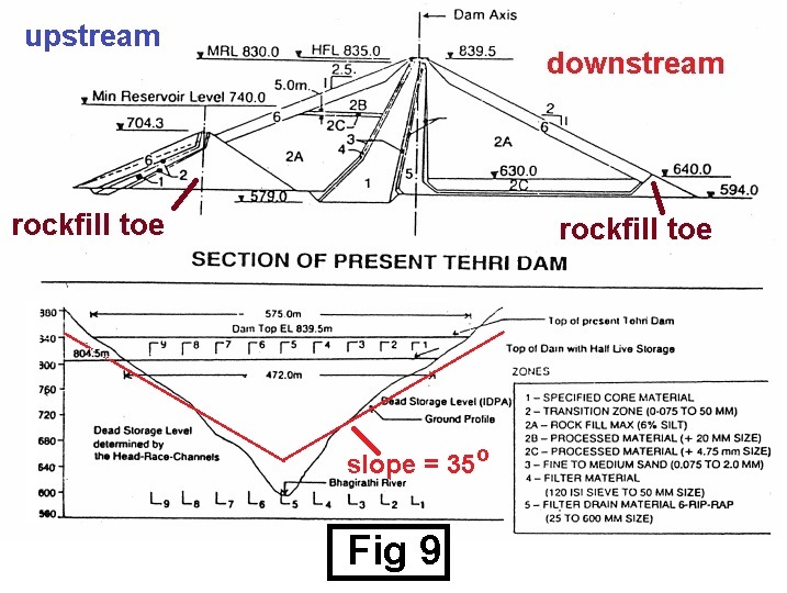
A cross section of the Tehri dam (from How safe is the proposed Tehri dam to
Earthquakes, Iyengar, Curr Science 1993 vol 45) is given in Fig 9. The
length across the valley at the crest is ~ 575 m while the base width in the
upstream-downstream direction is ~ 1000 m at the base and nearly 20 m at the
crest. The design requires an impervious core made up of clayey materials and a
shell of graded gravel that is topped with blasted rock which should be massive
and mostly quartz. Among many issues of concern and that I have no certified
expertise on are the stability of the dam itself to earthquakes, the stability
of the surrounding slopes to mudslides and collapse, as well as the stability
of the dam itself to settlement. The first of these that I take up is the very
simple one of the nature of the rocks used.
As an
unexposed layman I was under the impression that the rocks of shell (in region
marked by number 6 in Fig 9, top) the rock-fill dam would have to be some
species close to igneous rocks. This is
the case for the Thomson Dam, Victoria, which is nearly 165 m high (Fig 10,
right). The reason that granite was not used was probably because no granite
was available nearby although I am told (Valdiya, ) that the Lesser Himalaya terrane of Utterakhand where the
Tehri dam is located “… comprises
autochthonous *
geologic feature that
was formed from earliest times in the area where it is found) sedimentary succession thrust over by sheets
or nappes (large sheetlike body that has been moved a few kms over a thrust
fault) of metamorphic rocks associated
with granites occurring as prominent components all through the length and
breadth of the thrust sheets” (whatever that means). Since starting this series of
blog and since learning a little bit more about the Himalays I found from
photos (Fig 10, left is upstream side; fig 10, middle is downstream side) on
the internet (the last time I visited Tehri was nearly 35 years ago!) that the
sides of the Tehri dam were far from what I had visualized. The Tehri dam sides
were similar to the downstream side of the Nurek Dam, Tajikistan, the highest
earthfill dam in the world. The nature
of the placement of the rock is hardly confidence inspiring, especially when
one sees the shadows in Fig 10, middle. The shadows seemed to me to highlight
the rather fragile nature of the rockfill as compared to that of say, the
Thomson dam or even the Nurek dam.
These rocks
on the surface are supposed to be between 25 mm to 600 mm size or between 1”
and 2 ft size as per the drawing in Fig 9 bottom. Because of the black color of
the wet rocks in the landslides shown in Fig 6, right, I was worried that the
rocks on the outer of the shell could be low grade Phyllite II or III which has
clayey components. Since the sourcing of the rocks could not be from far away. The
position of the sun may have enhanced the black color of the rocks on the
surface. This becomes obvious when compared to the color of the rocks in Fig
11. However, since the rocks are quarried from nearby hills, It is is quite
likely that they are of low grade phyllie rocks. As seen from Fig 4, right,
most of the slopes on the hills are of grade II or III phyllites. These have
not been classified as arenaceous (mainly sand/quartz type).
I
learnt, from
a report presented in the World Tunnel Congress of 2008 on Geotechnical
investigations in the planning of powerhouse complex of Tehri dam project
(Stage-I) India from the Gelogical Survey of India, that the rocks used for rockfills were
obtained from Old Dobata borrow (borrows are pits created to provide earth
that can be used as fill at another site) area that lies approximately 5 km upstream of dam site
on the right bank of Bhagirathi river (Dobata had been proposed as an alternative site
for the Tehri dam; the Dobata) and
new Dobata borrows in Tehri
Garhwal district.
These rocks are technically described as tabular grains, equigranular, granoblastic
(fragments are irregular) in texture, and metamorphosed from sedimentary rock
sandstone.
The main
difference between the New Dobata borrow and the Old Dobata borrow is that the
former had nearly 99% quartz and were white in color while that from the Old
Dobata borrow had 96% quartz with more garnet and mica. This suggested to me
that the rocks from the old Dobata borrow were more clayish. The old Dobata
borrow rocks should not have been used for the top cover.
There
seems to be some arbitrariness in the way the rock/earth were chosen and used
in the earth rockfill Tehri dam. I learnt some of this from a judgment on 13 July, 2007 from the bench of B D Ahmed of
the Delhi High Court on Tehri Hydro Development Corporation
vs Lanco Construction Ltd. (LCL) (http://indiankanoon.org/doc/1046639/)
for a case that started in 1998! This judgment seems to have been delivered
after the dam had been built (this is not unusual).
The case dealt with “…
quarrying from Dobata borrow area, transporting and spreading shell material in
uniform layers of specified thickness in shell zone including dressing,
watering compacting up to required density with all leads and lifts etc.
complete as per specification.” This seems to suggest from Braithwaite’s
(Part 2: History of Rockfill Dam Construction) that the nature of dam
construction (which first started in 1970) corresponded to the the third
milestone:- “The third milestone
covers the time period from the 1940’s to 1950’s in which the dry rock dump
placement continued, except the dry and loose rockfill lifts were wetted to promote
self-weight settlement during construction of the larger rockfill dams.” The wet rock stone
dump technique was discontinued after 1965 for large rock fill dams in the rest
of the world. In the fourth milestone after 1960’s “… rockfill construction changed from wet rock dump placement in
relatively thick loose lifts to compacted rockfill placement in thin controlled
lifts for heavy roller compaction.” When work on Tehri dam was commenced,
the third milestone would have been the appropriate technology considering that
Indian technology has, at least at that time.lagged 10-20 years behind.
The
contract required that the shell material for dam fill (Zone 2A) shall be
obtained from Dobata borrow area which lies approximately 5 km. upstream of dam
site on the right bank of Bhagirathi river with existing level at 705M from
MSL. The” … material for (Shell zone 2A)
shall be obtained from this borrow area by selective borrowing and would in
general require … stripping top soil and removal of particles larger than
600mm. size in borrow area.” The contention for the case according to LCL
was that the
“... the new Dobata area, which was designated as a borrow area in the
contract for the shell material, was not available and they had to obtain the
shell material from the old Dobata area which involved a longer lead.
I do not know precisely what
difference it would have made to the engineering aspects when rocks from old
Dobata were used instead of new Dobata borrows to cover the rock shell (region
6 in Fig 9, top). I have not found any specific information from the internet
on whether the rocks from the Dobata borrows were (sandy non-wetting) arenaceous
or (clayey-wetting) argillaceous. From what I have discussed above, it seems to
me that the rocks from the new Dobata borrow had more quartz or were more
arenaceous and therefore should have been used for the outer shell (region 6,
of Fig 9, top) from a technical viewpoint. The contractor may have made a serious
mistake by using rocks from Old Dobata instead of New Dobata for the outer
shell.
What puzzled me was the seemingly
arbitrary way the contractor made the decision of using rocks from old Dobata
area as shell material instead of rocks from the New Dobata borrow simply
because they were “no available!
The rules for the
rockfill contract that I learnt from the 2007 Ahmed judgment cited above, gives
the impression that the technical expertise for the job is left to the
contractor. Part of it is the following:-
The Contractor shall be deemed to have satisfied himself before
tendering as to the correctness and sufficiency of his tender for the works … which
shall … cover all his obligations under the contract and all matters and things
necessary for the proper execution and completion for the works in accordance
with the provisions of the contract and its maintenance during construction. … In case of disagreement between technical provisions and
drawings, the technical provisions shall govern the contract. Should any
discrepancies however appear or should any misunderstandings as to the meaning
and interpretation of the technical provisions or drawings or dimensions or the
quality of the materials for the proper execution of the work or as to the
measurements of quantity and valuation of the work executed arise under this
contract or in respect of extra item, the same shall be clarified by
Engineer-in-Charge.”
One
could assume that the contractor may not have as much knowledge as those from good
universities regarding latest developments in building dams as, for example, in
Braithwaite’s fourth milestone that was adopted for building tall dams. Nor, as
is likely, was the contractor aware of the differences between the various
grades of phyllitic rocks in the surrounding slopes and their response to
various soaking in water.
Choice of dam site
Because
of the very nature of the requirements for tall dams on main rivers, geological
boundaries such as thrust lines or major faults are not uncommon, since they provide
the necessary geomorphological features. Major fault lines are known to exist
at the Tehri dam site (Fig 4, right). Any tall dam is a geological risk. Some
of the features that rquire to be taken intoaccount are given in Fig 11 (taken
from the reference given in Fig 11).
Perhaps
the first and most important requirement these is that the rocks adjacent to
the dam or on the sides of the river should be stable to sliding when wet. The
condition for these has been discussed above with Fig 2 in mind. For economic
reasons, the abutments also provide construction materials (Fig 9) such as clay,
filter sand and
gravel
and stabilising rockfills. Phyllitic rocks provide a good source for such
materials from a contractor’s point of view. This view many times over-ride the
safety point of view should the Engineer-in-charge be malleable (friendly to
the contractor) and the population be sufficiently gullible or just
indifferent.
The
slopes of the banks of the river (Fig 4, right) are dominated by Debris or
remains of broken rock because of high levels of fracture, and faulting (of the
earthquake kind) and sedimentation. As discussed above hydrogeological reasons
such as low grade phyllitic rocks in the abutments and rim slopes with
increased soil moisture due to soaking by the increased height of the
reservoir, could lead to a sliding of bedrocks and cause large landslides, As
long back as 1983 Mazari of the Wadia Institute of Himalayan Geology had warned
about the dangers of landslides on the rim slopes when water is withdrawn from
the reservoir for whatever purpose. These landslides would increase the
sedimentation rate and drastically reduce the dam’s life for power generation
or irrigation.
Because
of the high levels of fracture and sandy character the slopes of the hills are
expected to be close to the critical angle of 35o as predicted in
the sandpile model. This is what is found (Fig 9, bottom) for the higher parts
of the slope. The lower regions of the surrounding hills (Fig 9, bottom) have a
slope considerably larger than 35o, however. One may therefore
expect these slopes to slide and slip, especially if they soaked and wet as
when the reservoir is full. As mentioned earlier, signs of such sliding are
seen for the “crocodile” in fig 6, top left.
There are reports on the net (Down
to Earth, June 30 2007, by B. Kumar) that after the reservoir started filling
(2007) to levels above the old Tehri town, there have been landslides, caused by
heavy rains and cloudbursts, on the slopes abov the reservoir level. The
frequency of these landslides had been “growing exponentially”. Some of the reported
villages affected by these landslides are mainly on the eastern side (Fig 12).
In the context of water
seepage in dams, an worrying aspect seems to be that the water level did not
rise as fast as it should have and that the reservoir level went down faster
than it should have. An article in Hindi by Rai and coworkers published in a
CSIR journal in June 2012 reported from their oxygen (18O) and deuterium (2H) stable isotope studies
that the main source of water loss from drainage galleries is due to seepage into
the reservoir. It is this kind of seepage into the reservoir abutments in the
early stages of filling that causes landslides on the shores.
One of the more well known
disasters coming from dam building is that associated with the Vallont or
Vajont (l and j silent in both cases) dam (262 m high) built over the Vallont
(or Vajont) river in Italy. Because of the wetting of the abutments and nearly
a quarter million cubic kilometer of rock from Monte Toc (1920 m height) slid
into the reservoir at something like 100 miles per hour. It set off a 200 metre
tall (ten time larger than the Kedarnath tsunami hight) tsunami wave that spilt
over the dam wiping out the town of Longarone in the Piave Valley killing
~ 1500 of its residents and ~ 2000 altogether!
The name Monte
Toc is equivalent to “Mountain that Walks” which came because of frequent
landslides etched in the minds of the local people. It seems that in prehistoric- (paleo-) times there
were landslides from the slopes which had stratified layers of limestone rock and
clay-like layers. The sliding motion started with the weaker clay-like layers,
as discussed in the context of Fig 2. When the river Vajont started to flow it
cut through the stratified base. Removing the clay and leaving the rock behind,
giving the “rocky” foundation for building dams. When the dam started filling,
more clay layers got soaked and Monte Toc slid again almost immediately with
the disastrous results.
The Tons thrust (see Fig 14), now deemed to be
active by Sandeep Gupta et al, has
recorded geomorphoogical features including pulses of movement and uplifts and
huge fans of debris avalanches.
The Vallont dam stands today although it is not in
use. The engineers of the Vallont dam insisted that their design was perfect
and the dam was strong, It is only the mountains that were weak! This is a
classic example of patient-dead-operation-successful.
Engineering designs must include the whole
landscape. Local wisdom must be adhered to. The builders of the Tehri dam have
also ignored the warning of the local people.
It is not necessary that the mountain side has tall
unstable peaks for Vallont-dam-like disaster to strike. It is sufficient that
the weakness of the mountain side extends over large distances and that is
slides suddenly, say, when triggered by an earthquake of moderate
intensity.
It should be remembered that the stability of the
hill slopes depends on the extent of soaking. For dry sandy (arenaceous) conditions,
the critical slope angle is 35o. If the entire slope was to attain
this critical angle (indicated by red line in Fig 9, bottom) the level of the
bottom of the river would rise roughly to 650-660 ft. Flood waters from higher
ranges would fill the river up further. It is not difficult to find that the
cumulative effect of increased floods and soaking of the hillside could have
severe (not locally unexpected) consequences.
A cursory glance at pictures involving Tehri dam helps
us to examine the changes in the hill slopes with periodic filling and emptying
of the Tehri dam. The width of the “raj darbar” hill, seen in the insets of Fig
6, top left, seems to have reduced considerably from 2006 (left inset) when the
hill had its side covered with vegetation to later times (2012, right inset)
when the sides of the hill slid into the reservoir. Perhaps a more convincing
demonstration of landslides due to wetting may be seen from Fig 13. In this figure
I show pictures from the net at various times. The features marked by circles
show the changes with time. The reservoir level is close to 740 m between March
and May (Fig 12, right, from data of Rai et
al)). It seems clear that in the picture of April of 2012 (Fig 13, bottom,
left) there has been a landslide as compared to that of March 2008 (Fig 13,
top, right).
Another question of interest in the context of water
seepage into the reservoir sides is the changes in the level of water, DL, with time. From Fig 11, right the level of water
changes by ~ 80 m in height. This is to be compared with the changes of ~ 50 m
with the Nurek dam. The reservoir volume, V, of the Nurek dam (` 10.5 km3)
is nearly four times as much as that of the Tehri dam (~2.5 km3).
The mumber, N, of Francis turbines for the Nurek dam (the world’s highest operating
earth fill dam) is nine while for the Tehri dam N = 4 with nearly the same
power generating capacity per turbine. The value (VNDL)Nurek/(VNDL)Tehri = 1.12 which (very roughly)
indicates that the level of seepage (if any) into the reservoir sides for the
two dams are nearly the same given the very rough estimates used here.
The critical state of threshold landscapes
always keeps the landscapes susceptible to long-range instabilities such as
earthquakes because of the way the parameters change with time due to the
building of the dams. This need not be due to faults appearing directly on the
dam, but because the water stored in the reservoir affects the way the banks of
the reservoir changes due to new stresses or hydrogeology. The change in the
strength, DS, is dependent on the
changes in shear stress across a fault in the direction of slip, pore pressure
(see Fig 2), and the coefficient of friction (decreases on soaking). Failure
occurs when DS decreases below a threshold level.
The manifestation
of such changes is usually seismic in nature.
There are
basically two types of seismicity that may be induced by the reservoir of
water. The load of the water in the reservoir following filling with water
causes changes in elastic and shear parameters that leads to seismic activity
almost immediately (“initial seismicity”). Alternatively, the effect may be
slow (“protracted seismicity”) due to a slow seepage of water and may appear
after several cycles of filling and emptying of the reservoir. This would lead
to a new self-organized critical state that would later be vulnerable to
relatively small changes in the water level or even the rate of filling.
Such effects have been studied for the
rock-earthfill high Nurek dam which it was commissioned in 1972. The reservoir
induced seismicity has increased four times with more than 1800 earthquakes (1.4 > M > 4.6) occurring in the first nine years. Periods of high seismicity
appears when the water level is higher by 10 m than its previous maximum level.
The seismicity is also increased in the Nurek dam by changes in the rate of
filling of the reservoir even by rates as small as 0.2 m to 0.5 m/day. Dam
induced seismicity due to changes induced in the early stages (by the load of
the water) may be 10-15 kilometres away from the dam. As the banks of the
reservoir get soaked the seismicity moves closer to the dam.
If the Uttarakhand hills are
fragile, the hills of Assam/Arunachal-Pradesh must be more so. These ranges
have been the route through which the alluvial soils, that constitutes the
massive Bengal fan, have been transported (see my blog of 2nd Aug
2013) through the eastern Himalayas bordering Arunachal Pradesh, Assam. It must
be extremely sandy and fragile. It would seem that around 150 dams are proposed
for construction in these hills without assessing the cumulative impact of all
these dams,
The biggest project in these
areas is the lower Subansiri dam. This dam is founded on sandstone
“… which really looks and behaves like a
sand rock…”. Naturally, one has to
worry about the competence of the foundation to support the planned concrete
gravity dam. What is also worrying is the plan to release in winter to release
about 400 times more water per sec in the night than it would in the day (~ 6
cu m/sec).
Local wisdom/sentiments have been
vehemently against the project leading to more than 1000 crore over tun costs
with only 65 % project completed. Some leading political parties have even
proposed that the project be completed under military governance.
A 2012 artcle by
Sandeep Gupta et al have found that
within a radius of 20 km (Fig 14, right) from the Tehri dam there are new
earthquake pattern with dominantly thrust mechanism that closely follow the
Bhagirathi river. These earthquakes follow the Tons Thrust (TT) line in the SW–NE
cross-section through the Tehri dam (Fig 14). The TT thrust is thus a newly
activated fault.
As the
song may have gone, Dead Faults never die, they simply reappear.
Since I
come from Pune in Maharashtra, I become more worried, when I remember that the
massive 1993, Killari, Latur earthquake when a new fault appeared in the
seemingly inert (dead) Mesozoic (when the middle reptile appeared on earth
250-70 billion years ago; much before Himalaya) basalt flows. Should an earthquake really happen the engineers
and designers and contractor may all say “its not my fault” that a fault appeared.
On the other hand, as it is likely,
the thrust fault may have been activated by filling of the dam. Prior to the
filling of the dam (which started in Oct 2005) all the recorded earthquakes
were to the north of the dam. The new earthquakes came after the filling of the
dam. In this case the fault reappearance could have been anticipated, and the
engineers and designers and contractors may be accused of being at fault.
It is also a matter of concern that
seepage below the dam, as in Fig 11 bottom right, may have occurred to destabilize
the slopes further down the dam, to create new earthquake regions.
It has been argued that earthquakes
occur because of release of tectonic strain that is built-in into the landscape
during the formation itself. This strain would be released naturally in any
case with or without the creation of the reservoir. The reservoir only hastens
the process. I have not lived long enough to experience such things and form an
opinion. I suppose that the building of the reservoir hastens the chain of
hierarchical events that trigger earthquakes, sometimes as a series of
foreshocks“initial seismicity”.
It
is generally agreed that a reservoir, by whatever physical mechanism, is only
triggering the release of natural tectonic strain, and is not in itself
generating the principal seismic energy. Therefore one might argue that the
presence of the reservoir has only hastened the arrival of an event that would
have happened at a later time anyway. On the other hand, one can argue equally
well that many areas of the earth's crust are very close to the breaking point
on a more-or-less continuing basis, as might be envisaged from the concepts of
plate tectonics. Only when a perturbing phenomenon is introduced, such as a
large reservoir, is the breaking strength locally exceeded. This blogger
prefers this second point of view and therefore argues that the seismic history
of a region, even if extending over many hundreds of years, is not an adequate
guide to the maximum credible size of a reservoir-induced earthquake in the
region.
Just as observed in the case of the
Nurek dam, Gupta et al find in their
study between 2005 and 2008 that earthquakes are observed when the reservoir
level is maximum and also when it reaches the minimum. Such an observation
links the earthquakes in the vicinity of the Tehri dam to loading and unloading
of the reservoir levels that accompanies tectonic effects due to reactivation
of the Tons thrust. These earhquakes all have magnitudes less than 4 Mh.
Although they may not be dangerous to the safety of the dam itself, there is no
guarantee that there will not be continuous landslides on the shores of the
basin that could fill up the reservoir.
In
order that the probability of such a filling of the reservoir it is necessary
that population (anthropogenic) pressure is
minimized. In the case of the Nurek dam, such a pressure leads, among other
effects, to mass felling of trees in forests, livestock grazing that leads to
depletion of grass cover, construction of new irrigation canals and roads due
to the massive influx of population in the vicinity of the Nurek reservoir. In
the case of the Tehri dam such harm to the ecosystem has already taken place.
However, it is hydel-power activities that involve road-building, dam-building
in the upper Uttaranchal that adds to the pressure from activities of humans
(mainly Ram-worshipping, if not Modi-worshipping, businessmen from the plains)
that pose the real danger in the North east. These parts are, fortunately, not
in the domain of their pilgrimage.
Tunnel-less Alternative to
Power generation from streams.
Arunachal
Pradesh has a population density of less than 15 persons per square kilometer,
with > 80 % forest cover, > 50% of species of mammal and flora and fauna
found surviving in India. It has perennial mountain streams from the snow-fed
mountains with a hydel power-generating capacity of nealy 50 giga watts!!!. If
we are to preserve this wonderful piece of land, experience tells us that
hydroelectric power projects should be avoided, as the big players (L&T,
JP) and small players (Amar Singh and Amitabh Bachan?) must be finding out now.
What
is the alternative? The easy alternative is not to go in for power generation.
If at all power generation is considered imperative (I see no reason why it
should), we must become truly innovative, especially in a way that taps on our
ability to use computers. There are many ways in the net to generate power
including, say, inventing tiles which generate power when walked upon. Power
from micro-turbines (see, for example, A
Microturbine for Electric Power Generation, 2002) is long known and has
been used for generating power at a local village/town scale. These always
involve the building of a reservoir in the “mini” or “micro” scale although
such reservoirs have to be large in some way. The history of these reservoirs
always involves dam collapse and flash-floods which really does not help.
What
one may ideally want is a “nano” (if that is the word) turbine such as the
hand-held power generator in the hands of an angler (Fig 15, right). Unlike
other fisherman, he will be always catching power even when he is asleep.
The
concept in Fig. 15 right is only a beginning. The crux of this idea is that all
the I”nano”-turbines would be connected to a grid (appropriately, of course).
They would preferably require wireless power transmission (WPT) with its
advantages of reduced transmission and distribution losses.
It
was Nicholas Tesla who proposed the revolutionary Microwave Wireless
Transmission and worked on it in the Wardenclyffe project in Colorado. More
than hundred years Tesla visualized (in an article on “The Future of the
Wireless Art,” Wireless Telegraphy & Telephony, 1908, pp. 67-71) thus:-
"As soon as [the
Wardenclyffe plant is] completed, it will be possible for a business man in New
York to dictate instructions, and have theminstantly appear in type at his
office in London or elsewhere. He will be able to call up, from his desk, and
talk to any telephone subscriber on the globe, without any change whatever in
the existing equipment. An inexpensive instrument, not bigger than a watch,
will enable its bearer to hear anywhere, on sea or land, music or song, the
speech of a political leader, the address of an eminent man of science, or the
sermon of an eloquent clergyman, delivered in some other place,however distant.
In the same manner any picture, character, drawing, or print can be transferred
from one to another place ..."
All
that is said here has been realized with our ubiquitous mobile. It could happen
one day that the power transmission would also happen through the billions of
mobiles now available--- just as one does cloud computing with all the
computers?
In
this case power transmission using a mobile (Fig. 15, right) would be a cottage
industry without environmental damage
Why can’t this
dam-Blog be short?
This
blog is long especially because on a serious subject such as the Tehri dam, I
had to go through as much pros and cons as I could to answer the question in
the title. The Tehri dam is already dammed. From a constructive point of view
we have to be critical with as much knowledge as we can gather to see if it is
damned, if only to forewarn on the construction of other dams on similar or
worse Himalayan terrains.
As
usual my blog is rather long. Because I try to be correct (to a first
approximation) I succumb to, the consequences of what one may call, a BUP (Blog
Uncertainty Principle). As most people guess from a first response, the
readability of a blog is inversely proportional to the length of the blog. If
LOB is the length of a blog and RCB is the Research Content of Blog then the
BUP says that [LOB/RCB] = constant. The Readability of Blog, ROB, improves when
one has less number of cross-references to contend with. One usually finds,
[LOBxROB] = constant or readability increases as length decreases.
I
try to make RCB high for matters in which I am a layman. As a result, I guess,
my ROB could be low because of this “sincerity”. As Oscar Wilde said “A little sincerity is dangerous but a lot of
it is absolutely fatal,” I have no interest in killing this blog by its
length. Given the gravity of the matter as perceived by me, I prefer to be
fatally sincere. The ROB could become high if LOB is made small when the reader
reads it in parts.